Introduction: Why Traffic Intelligence Depends on Accurate Classification
Cities deploy thousands of traffic cameras to monitor roads, intersections, and public spaces. However, simply detecting movement does not deliver actionable insight. Urban planners and traffic authorities need to understand what type of object is moving, how it behaves, and how frequently it appears across locations and time. Video classification for GIS enables precise mapping of traffic patterns, object movements, and spatial insights, supporting data-driven decisions for smarter, more efficient urban infrastructure planning.
Therefore, smart city initiatives increasingly rely on video classification for GIS to categorize moving objects consistently across video streams. By classifying vehicles, pedestrians, and infrastructure elements at the video level, cities transform raw footage into structured traffic intelligence that supports planning, safety, and policy decisions.
As one urban mobility planner stated, “Traffic data becomes useful only when we understand who is moving and why.”
Table of Contents
What Is Video Classification for GIS?
Video classification for GIS refers to categorizing objects in video and aligning those object classifications with geographic information systems. Instead of labeling frames in isolation, annotators assign stable classes to objects as they move through space and time, while preserving spatial context.
Consequently, video classification for GIS enables:
- Consistent categorization of moving objects across camera feeds
- Integration of video-derived classes with GIS layers
- Longitudinal analysis of traffic behavior
- Spatial visualization of mobility patterns
As a result, cities gain a unified view of movement across their transportation networks.
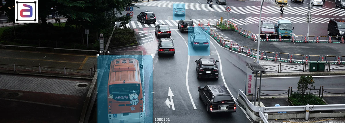
Traffic Objects Commonly Classified in Smart Cities
Urban traffic management depends on distinguishing between different types of moving entities. Smart city systems commonly classify traffic objects such as vehicles, pedestrians, cyclists, traffic signals, and road signs. Accurate classification enables real-time traffic monitoring, congestion management, accident detection, and improved urban mobility through data-driven insights. Commonly classified objects include:
- Emergency vehicles (ambulances, fire trucks, police)
- Public transportation (buses, trams)
- Private vehicles (cars, motorcycles)
- Commercial vehicles (trucks, delivery vans)
- Pedestrians and cyclists
By classifying these objects accurately, traffic systems respond intelligently to real-world conditions.
How Video Categorization Supports Urban Traffic Management
Video categorization enables cities to move beyond basic traffic counts. Instead, planners analyze behavior and class-specific trends.
For example:
- Emergency vehicle classification improves signal prioritization
- Public transit categorization supports route optimization
- Pedestrian and cyclist classification informs safety planning
- Commercial vehicle tracking aids freight and zoning decisions
Therefore, video classification for GIS directly supports smarter, safer streets.
Challenges in Classifying Traffic Objects from Video
Traffic video introduces complexity that annotation teams must address carefully.
- Camera Diversity: Different angles, resolutions, and mounting heights
- Environmental Variation: Weather, lighting, and seasonal changes
- Class Imbalance: Rare but critical objects, such as emergency vehicles
- Occlusion: Vehicles blocking each other in dense traffic
Because of these challenges, consistent video-level classification becomes essential for reliable analytics.
Annotation Strategies for Smart City Video Classification
To ensure accuracy at scale, annotation teams apply structured strategies.
Context-Aware Classification
Annotators consider road type, traffic flow, and environment. Consequently, classification remains accurate even when appearance varies.
Temporal Validation Across Feeds
Reviewers validate object classes across multiple frames and camera views. As a result, labels remain stable over time.
Class Normalization for GIS Integration
Teams map video classes to standardized GIS categories. Therefore, video data aligns with planning systems seamlessly.
Why Cities Outsource Video Classification for Traffic Management
Smart city programs operate at scale while facing strict accuracy requirements. Therefore, many municipalities outsource video classification for GIS to specialized providers.
Outsourcing helps cities:
- Scale classification across large camera networks
- Maintain consistent object taxonomies
- Accelerate deployment of traffic analytics
- Reduce operational complexity
As a result, urban teams focus on planning while annotation partners handle data quality.
Annotera’s Video Classification Services for Smart Cities
Annotera delivers service-led video classification for GIS designed for urban traffic environments:
- Annotators trained on traffic and mobility scenarios
- GIS-compatible classification outputs
- Scalable workflows for city-wide deployments
- Multi-stage QA focused on temporal consistency
- Dataset-agnostic services with full client data ownership
Key Metrics That Matter in Smart City Video Classification
| Metric | Why It Matters |
|---|---|
| Class Accuracy | Ensures reliable traffic categorization |
| Temporal Stability | Prevents class flicker across frames |
| Spatial Consistency | Aligns video with GIS layers |
| Coverage Balance | Captures rare but critical objects |
Because traffic decisions affect public safety, these metrics directly influence outcomes.
Conclusion: Turning Traffic Video into Urban Intelligence
Smart city traffic management depends on understanding movement at a granular level. Without accurate categorization, video remains underutilized.
By leveraging professional video classification , cities convert traffic footage into actionable intelligence that improves mobility, safety, and planning. Ultimately, consistent classification empowers data-driven urban decisions.
Building smarter traffic management systems? Annotera’s video classification services for GIS help cities transform traffic video into structured, actionable insights.
Talk to Annotera to define traffic object taxonomies, run pilot programs, and scale video categorization across urban networks.